Ever wished you could explore and document environmental features in more detail than what Google Street View offers? While Street View provides a fantastic glimpse into various locations, it often lacks the depth and flexibility needed for comprehensive environmental mapping. This is where OcuMap steps in, a powerful environmental mapping software designed to empower researchers, conservationists, and land management professionals.
What is Environmental Mapping Software?
Environmental mapping refers to the process of creating detailed visual representations of natural landscapes and their associated features. These maps can encompass a wide range of elements, including:
- Topography (elevation, slope)
- Vegetation types and distribution
- Water resources (wetlands, rivers, streams)
- Soil types
- Wildlife habitat areas
- Human impacts (development, agriculture)
Environmental maps play a crucial role in various fields, such as:
- Ecological monitoring: Tracking changes in ecosystems over time and identifying areas of concern.
- Conservation planning: Prioritizing areas for protection and informing conservation strategies.
- Land management: Making informed decisions about resource use and sustainable practices.
- Environmental impact assessments: Evaluating the potential impact of development projects on the environment.
Why Use OcuMap for Environmental Mapping?
While traditional methods of environmental mapping involve ground surveys, aerial photography, and satellite imagery, these approaches can be time-consuming, expensive, or limited in detail. OcuMap offers a unique and user-friendly alternative, addressing these limitations through several key features:
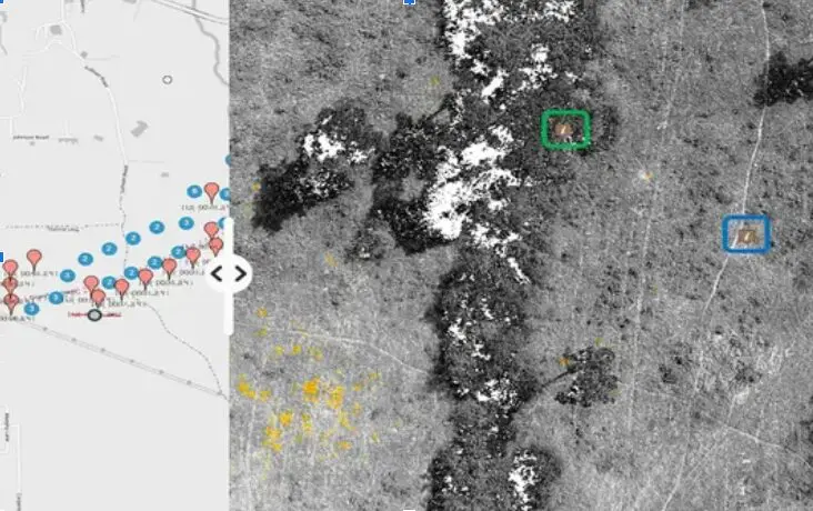
- Go Beyond Google Street View: Unlike Street View’s pre-recorded footage, OcuMap allows you to capture your own data using GPS-based photos or videos. This enables you to access remote areas, capture specific features of interest in greater detail, and revisit the same location over time to monitor changes.
- Capture Data on-the-Go: With OcuMap, you can collect data using various methods – walking, biking, or even flying a drone over the area of interest. This flexibility allows you to choose the most efficient approach based on the terrain and scale of your project.
- Effortless Data Collection: OcuMap empowers you to collect data using any GPS camera that records video or photo. This eliminates the need for manual geo-referencing later, saving you significant time and effort.
- Tag Points of Interest: Easily identify and tag specific features of interest directly from your photos within OcuMap. This could include anything from unique plant species to signs of erosion or pollution.
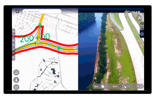
- Data Visualization and Sharing: OcuMap allows you to publish your collected data either privately or publicly on a user-friendly map interface. This facilitates collaboration with colleagues and stakeholders, enabling them to visualize the data and gain valuable insights.
- Easy-to-Use Interface: OcuMap boasts an intuitive interface that doesn’t require extensive GIS expertise. This makes it accessible to a broader range of users, from experienced environmental professionals to citizen scientists.
How Does OcuMap Work?
Using OcuMap for environmental mapping involves a straightforward workflow:
- Planning: Define the area of interest and determine the specific features you want to capture. This might involve consulting existing maps, satellite imagery, or other relevant data sources.
- Data Collection: Head out to the field with your smartphone or a compatible GPS device. Use the OcuMap app to capture photos or videos while navigating the area. The app will automatically record the GPS coordinates for each data point.
- Tagging Points of Interest: Review your captured data within OcuMap and identify any specific features that require further attention. The software allows you to tag these points with labels, descriptions, or even photos for enhanced clarity.
- Data Processing and Analysis: Once you’ve collected your data, OcuMap helps you organize, analyze, and visualize it. You can create custom maps that highlight specific features, overlay additional data sets, and generate reports based on your findings.
- Data Sharing and Collaboration: OcuMap empowers you to share your environmental data with colleagues, stakeholders, or the public. You can control the access level and choose the level of detail you want to publish. This fosters collaboration and facilitates informed decision-making.
Benefits of Using OcuMap for Environmental Mapping Software
- Increased Efficiency: OcuMap streamlines data collection compared to traditional methods, saving you time and resources.
- Improved Data Quality: Capture high-resolution photos and videos with accurate GPS data for detailed and reliable environmental mapping.
- Enhanced Accessibility: Reach remote areas and capture data from diverse terrains using various data collection methods.
- Simplified Data Management: Organize, analyze, and visualize your data efficiently within the user-friendly OcuMap interface.
- Effective Communication: Share your environmental data with stakeholders through clear
Who Can Benefit from OcuMap?
OcuMap’s versatility makes it a valuable tool for a wide range of professionals and organizations involved in environmental research, conservation, and management. Here are some specific examples:
- Researchers: Ecologists, biologists, and other researchers can utilize OcuMap to conduct field studies, monitor specific locations over time, and document changes in ecosystems. The ability to capture detailed data and easily share it with colleagues fosters collaborative research efforts.
- Conservationists: Land trusts, wildlife agencies, and conservation organizations can leverage OcuMap to identify and map critical habitats, track wildlife populations, and monitor the effectiveness of conservation initiatives. The platform’s user-friendly interface allows citizen scientists to contribute valuable data collection efforts.
- Land Managers: Forestry departments, park rangers, and land management agencies can use OcuMap to assess land resources, monitor for invasive species, and plan sustainable management practices. The ability to visualize data on a map helps identify areas requiring specific attention and facilitates informed decision-making.
- Environmental Consultants: Consultants working on environmental impact assessments can utilize OcuMap to collect baseline data, document existing conditions, and assess potential impacts of development projects. The platform’s data sharing functionalities enable transparent communication with clients and regulatory agencies.
- Educational Institutions: Universities, colleges, and environmental education programs can leverage OcuMap for hands-on learning experiences. Students can participate in data collection projects, analyze environmental data, and gain valuable insights into ecological processes.
OcuMap is constantly evolving, with new features and functionalities being added to enhance its capabilities. Contact for a Free Trial now.