Bring the site into your office and get visual-actionable Insights from your data.
OcuMap is an innovative mapping software that combines Reality Capture, GIS and BIM to better manage your assets, optimize operations, and make more informed decisions.

Leverage GPS Images for Virtual Inspections
Use any GPS camera to collect your photos, including smartphones, then group your photos by project name and annotate them based on location. You can also link maintenance documents to photos based on geolocation. Share your comments with your team and increase inspection efficiency by 30%.
Drag and Drop Thousands of Photos and See them On the Map
OcuMap allows you to see where your data is located, instantaneously. Navigate from one image to another. Pan around in 360 and zoom in and zoom out to see the big picture. Plus, get the GPS coordinates of each photo using EXIF data.

")
Upload, view and Share your Revit files
You can simply upload and share your Revit files online with other team members, clients, or project stakeholders to ensure consistent project delivery and streamlined progress communication.
Key Features

Publish photos on the map

Publish videos on the map

Publish CSV on the map

Publish GLTF on the map

Extract Point features
from images and videos

Publish KMZ on the map

Publish KML on the map

Group your Map Data

Publish GPX on the map

Publish XML on the map

Address Geocoding

Embed in your website
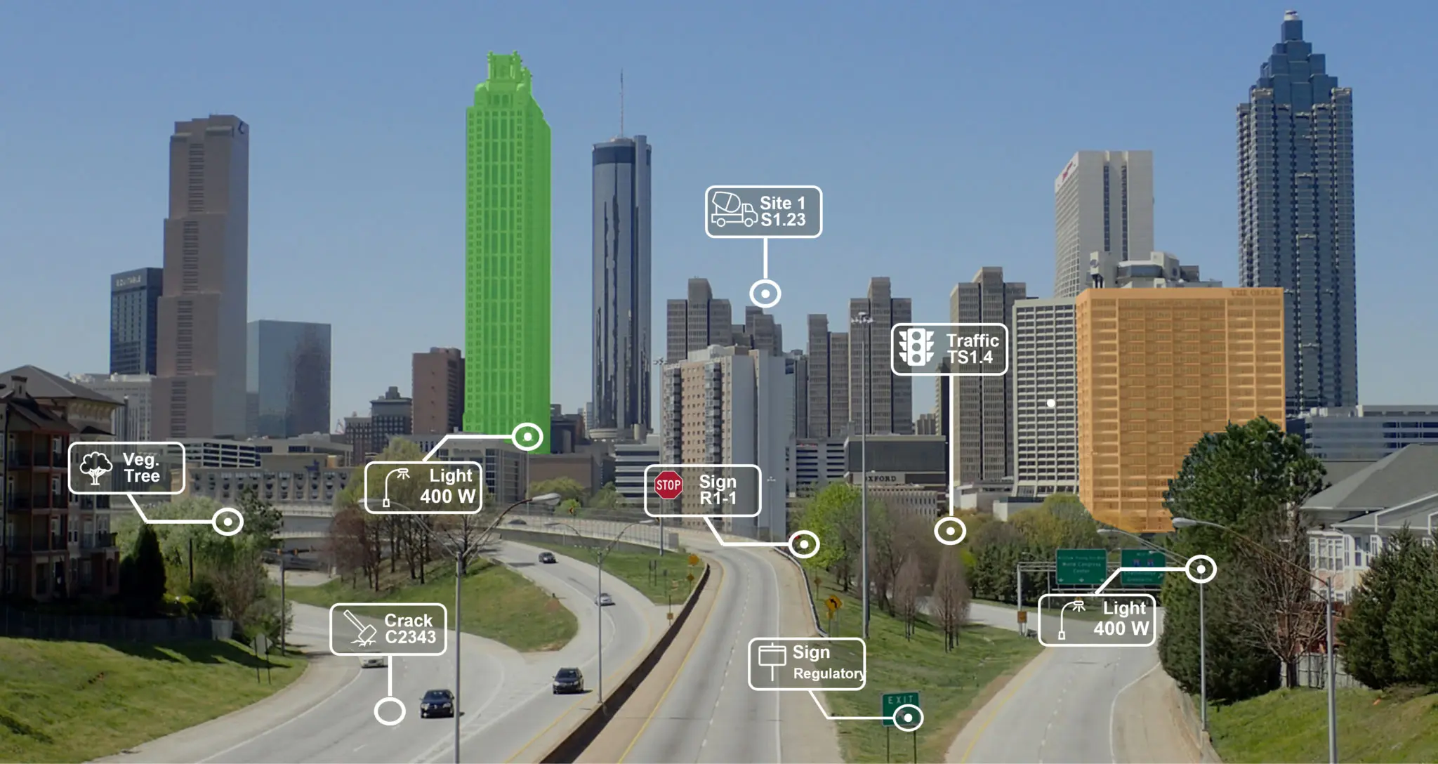
Tag Street assets and Generate Asset Inventories
An innovative asset inventory tool, OcuMap generates asset inventories directly from images. For further GIS analysis, simply export your data in CSV format.

The highest possible security to keep your data safe
- Data is encrypted using 256-bit Advanced Encryption Standard (AES)
- Authentication system protects against unauthorized access to keep your data secure
- OcuMap uses Secure Sockets Layer (SSL)/Transport Layer Security (TLS) to protect data in transit between web application and our servers
Frequently Asked Questions
OcuMap is an innovative mapping platform that helps you combine Reality Capture (images), GIS (location) and BIM (3D) to better manage your projects, optimize operations, and make more informed decisions.
OcuMap is used by:
Project Managers who need visual documentation of their infrastructure projects.
GIS experts who need to extract features directly from imagery.
City Planners who need better understanding of the streetscape
Right of Way Engineers to plan maintenance.
Civil Engineers to Assess Roadway Damages
Environmental Scientist for NEBA
OcuMap can be used in many different industries, whether in engineering and construction, petroleum, roads, transportation, or local government
You can use any GPS-enabled camera. OcuMap supports .mp4 video files and .jpeg image files. If you are recording video with GPS, make sure you can export a GPS data file out of the camera in simple text format (txt, csv, xml) or GPX.
Create an OcuMap Account
Start visually mapping your data now with a 14-day free trial.
“OcuMap helped us locate assets within the ROW using panoramic images, a job that would not have been possible otherwise.”
WILLIAM BERNARD
CEO, REFLECTIVE LIGHT SCIENCE
Contact us
"*" indicates required fields