Interactive Map Builder

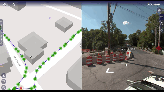
Interactive Map Builder: Crafting Customized Maps Made Easy

Creating customized maps has become an essential tool for businesses, educators, and governments alike, and interactive map builders make this process accessible and efficient. With an interactive map builder, anyone can transform complex data into visually engaging, informative maps that...

visual representation map

Visual Representation Maps – Enhancing Clarity and Insight

Visuals are essential for understanding and communication in today’s data-driven environment. One of the best techniques for presenting complex information in an easy-to-understand manner is a visual representation map. When examining spatial data, project milestones, or data patterns, visual maps...

GPS Utility Mapping

The Power of GPS Mapping Apps: A Comprehensive Guide

Mapping technology is essential for navigating the digital and physical worlds in today’s fast-paced environment. The GPS mapping program has completely changed the way we track resources, navigate cities, and even preserve the environment. The capabilities of mapping apps have...

gps mapping software

GPS Mapping Software: Revolutionizing Navigation and Data Analysis

Today’s world demands efficiency and precision, and GPS mapping software has become a vital tool for data analysis and navigation. This technology has revolutionized the way we see and engage with the world, offering priceless information for a variety of...

Street Level Imagery Platform

Street-Level Imagery Platforms: OcuMap vs. Mapillary: Choosing the Right One

Mapillary is now owned by Facebook and it is a crowd-based platform that relies on contributions from users to create and maintain its street-level imagery and map data. Users can upload photos they’ve taken while walking or driving, and these...

visual representation map

Get Instant Access to the Best Free Interactive Map Online

An interactive map can be a very useful tool, regardless of your level of experience traveling or whether you’re just trying to discover new places in your area. The map is free of charge. These maps provide you with a...

gps mapping software

The Power of GPS Mapping Software: Revolutionizing Navigation and Spatial Data Management

Whether for urban planning, transportation management, or personal navigation, GPS mapping software has become a critical tool. The technology has evolved far beyond its original military applications, now serving various industries with unmatched accuracy and reliability.  What is GPS Mapping...

360 Video Mapping In OcuMap

What is 360 Video?

360 video, also known as Panoramic, Immersive or spherical Video is a term used to describe a hardware and software video technology that applies multiple camera sensors or lenses to record frames in all directions. These sensors are programmed or...

GPS cameras of 2020

Best GPS Cameras of 2020 Breakdown

Different circumstances call for different cameras. Having the right camera at the right time can take the final product from acceptable to truly impressive. Here is a guide to various camera types with the pros and cons of each and...

Roadway asset inventory

The Efficient Asset Inventory Solution

How to document assets within your city using an off-the-shelf GPS camera Mapping is essential for your projects. But infrastructure assessment, and asset inventory build can require expensive and time-consuming efforts such as multiple site visits, back and forth communication...