Railway Track 3D Mapping Software

The Role of Railway Track 3D Mapping Software in Modernizing Rail Networks

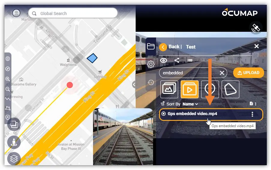
Railway networks are vital for the smooth functioning of transportation systems, whether for freight or passengers. With increased demand and the pressure to ensure reliability and safety, modernization has become essential for aging rail infrastructure. One of the technologies at...

environmental management

Interactive Mapping Software: A Comprehensive Guide

Interactive mapping software is a powerful tool that allows users to create, visualize, and analyze data on a map. It is used in a variety of industries, including business, government, and education. In this article, we will explore the best...

3D Mapping Software

3D Mapping Software/Solutions: A Detailed Guide

The digital world is becoming increasingly three-dimensional. From architectural design to urban planning, 3D mapping software is revolutionizing the way we capture, visualize, and analyze our physical environment. This comprehensive guide delves into the world of 3D mapping, exploring its...

Mobile Mapping GPS Camera Software-Geotagging-OcuMap

Best GPS Cameras for Mobile Mapping

Depending on the task at hand, you will find it difficult to choose the best GPS camera for your mobile mapping project. While there are many off the shelf GPS cameras available, you want to make sure you invest in...

Railway Track 3D Mapping Software

Benefits & Opportunities of Using OcuMap In Railway Mapping – Ocumap

One revolutionary solution that has been transforming the way we approach railway mapping is OCUMAP software. This cutting-edge technology offers a plethora of benefits and opportunities, positioning it as an indispensable tool for companies involved in railway development and maintenance....

EXIF data

What Does EXIF Data Mean In Mapping?

EXIF Data: How is it used in Mapping EXIF Data, which stands for “Exchangeable Image File Format,” is a set of standardized tags embedded within digital photos. It’s like a hidden document attached to each image, revealing valuable information about...

Rai Engineer-Right of Way Imaging and Mapping

Rail Engineers, Do you need a GPS video for your Right of Way?

Are you a rail engineers or a maintenance manager? if yes, then you probably know that inspecting a busy corridor could be time consuming and dangerous at times, but depending on the type of operation you are involved in, you...

Railroad 360 video Imaging and mapping is a technique which reproduces 360 videos and panoramic pictures of the right of way and tracks. 3D as-built.

Railroad 360 Video

Every railroad corridor requires a set of fiber optics cable network in order to keep it running but what does railroad 360 video mapping have to do with this? Like any other construction project, installation of a fiber optics cable...