The digital world is becoming increasingly three-dimensional. From architectural design to urban planning, 3D mapping software is revolutionizing the way we capture, visualize, and analyze our physical environment. This comprehensive guide delves into the world of 3D mapping, exploring its various functionalities, applications, and the best software options available.
What is 3D Mapping Software?
3D mapping software allows you to create digital representations of real-world environments. These representations come in various forms, including:
- Point clouds: Dense collections of data points representing the 3D geometry of objects and surfaces.
- Mesh models: 3D surfaces built from connected polygons, providing a more visually appealing representation.
- Terrain models: Digital representations of the Earth’s surface, including elevation and land cover data.
3D mapping software utilizes various methods to capture data, including:
- Terrestrial laser scanning (TLS): High-precision laser scanners capture millions of data points per second, creating detailed point clouds.
- Drone mapping: Drones equipped with cameras and sensors capture aerial imagery and LiDAR (Light Detection and Ranging) data for large-scale 3D mapping.
- Mobile mapping: Vehicles equipped with cameras and sensors capture street-level data while driving, ideal for urban environments.
By processing this captured data, 3D mapping software allows you to:
- Visualize complex infrastructure projects: Gain a clear understanding of construction sites, pipelines, power grids, and other structures in a 3D environment.
- Measure distances and volumes: Precisely calculate distances, areas, and volumes of objects within the 3D model.
- Generate reports and share data: Create detailed reports with embedded 3D models for project planning, stakeholder communication, and collaboration.
The Power of 3D Mapping Across Industries
3D mapping software finds application in a wide range of industries across the USA, including:
- Engineering and Construction: Manage infrastructure projects efficiently, visualize designs, and conduct pre-construction assessments.
- Oil and Gas: Map pipelines and storage facilities for efficient maintenance and leak detection.
- Roads and Transportation: Plan road expansions, assess pavement conditions, and conduct traffic flow analysis.
- Local Government: Create detailed 3D models of cities for urban planning, emergency response, and citizen engagement.

Choosing the Right 3D Mapping Software for Your Needs?
The vast array of 3D mapping software options available. Here are some key factors to consider when making your choice:
- Project Requirements: Identify the specific needs of your project. Do you require high-precision point clouds or visually appealing mesh models?
- Budget: 3D mapping software ranges in price from freemium options with limited features to professional-grade solutions with advanced functionalities.
- Ease of Use: Consider the user interface and learning curve associated with the software. Is it user-friendly for your team’s technical skills?
- Data Compatibility: Ensure the software supports your preferred data visualization methods (e.g., panoramic imagery, Revit, DWG, GPX, etc.) and file formats.
- Technical Support: Reliable customer support is crucial for troubleshooting and maximizing the software’s capabilities.
OcuMap: A Leading Solution for Remote Projects
OcuMap, a robust 3D mapping software solution. Here’s why OcuMap stands out:
- User-Friendly Platform: OcuMap boasts an intuitive interface, allowing project managers, GIS experts, city planners, and engineers to quickly upload and visualize 3D data.
- Direct Feature Extraction: Extract valuable features from GPS images and GPS videos, streamlining the process of creating detailed location-based assets.
- GPS Integration: OcuMap integrates with any GPS-enabled camera, including action cameras and smartphones. It also supports geo-referencing CAD and Revit models on the map for maximum flexibility.
- Wide Industry Applicability: OcuMap empowers professionals across engineering & construction, oil & gas, roads & transportation, and local government worldwide.
Applications of OcuMap in Various Sectors:
- Project Managers: Utilize OcuMap’s visual documentation capabilities for clear communication with stakeholders, boosting project efficiency and stakeholder alignment by up to 80%.
- GIS Experts: Extract features directly from imagery and videos with OcuMap, streamlining data collection and updating GIS databases.
- City Planners: Gain a deeper understanding of the urban landscape using OcuMap’s 3D models, facilitating informed planning decisions.
Beyond the general applications of 3D mapping software, let’s explore how it tackles specific challenges in various sectors:
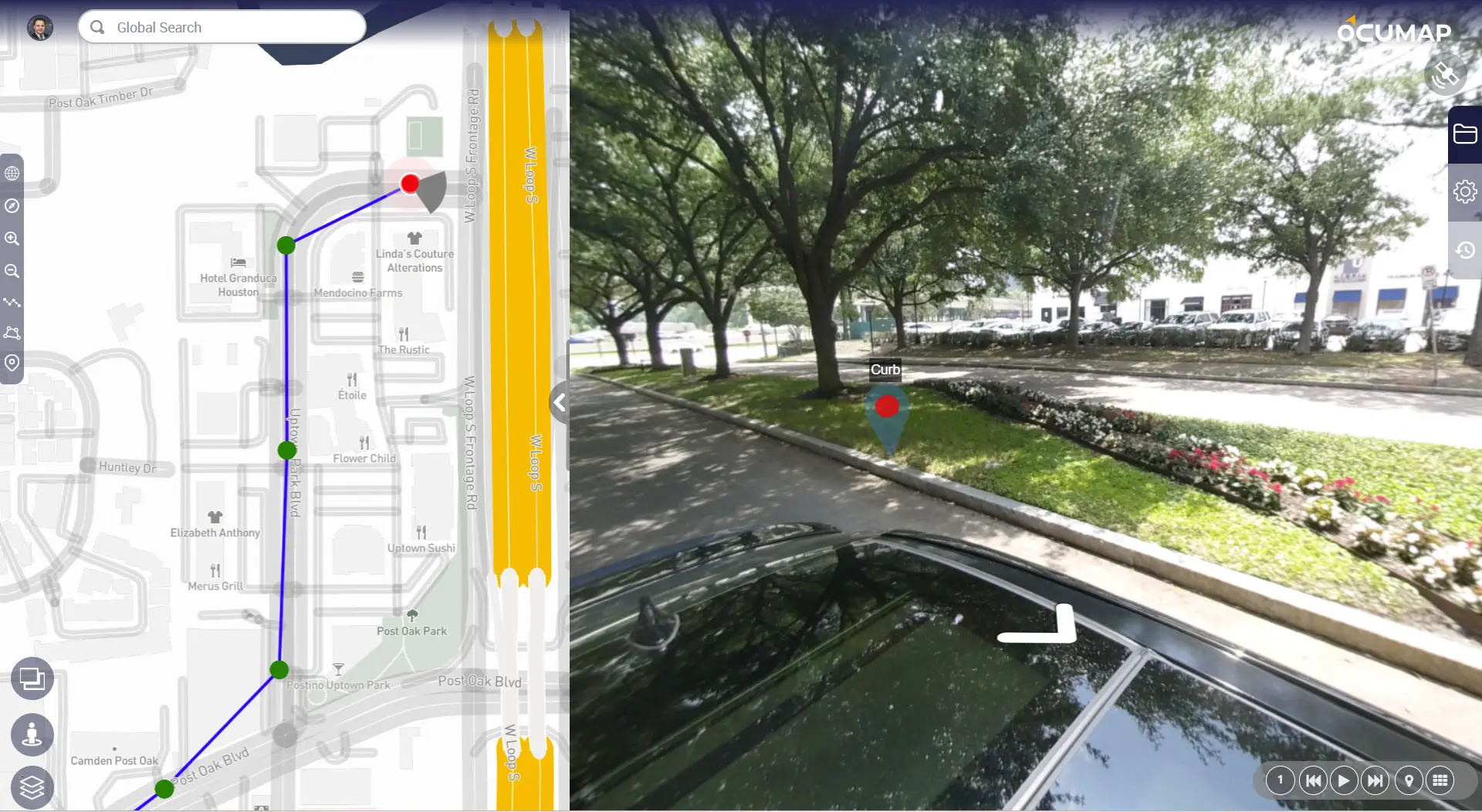
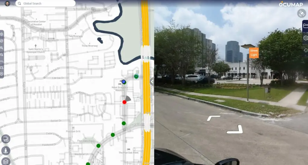
What is Street Mapping?
Street mapping utilizes mobile mapping technology to capture detailed 3D data and Panoramic Imager of urban environments. This includes:
- Road geometry with lane markings and signage
- Sidewalk infrastructure, including curbs and streetlights
- Building facades and storefronts
- Utility poles and overhead wires
Benefits of Street Mapping:
- Improved Infrastructure Management: Municipalities can use street maps to identify infrastructure issues like damaged roads or faulty traffic signals, facilitating maintenance planning and budget allocation.
- Enhanced Traffic Flow Analysis: 3D models of street networks enable traffic engineers to analyze traffic patterns and identify bottlenecks, leading to optimized traffic light timing and road improvements.
- Public Safety Planning: Emergency response teams can leverage street maps to plan routes, identify potential obstacles, and coordinate response efforts more effectively.
- Pedestrian Safety Assessments: 3D models allow for a comprehensive analysis of pedestrian infrastructure, including sidewalks, crosswalks, and signage, promoting safer walking environments.
Map Your Streets in 3 Easy Steps with OcuMap
Tired of complex street asset mapping? OcuMap makes it simple! Here’s how to get started in just three steps:
- Capture Everything with Your Favorite GPS Camera – No fancy equipment needed! Use any GPS-enabled camera you have, whether it’s your smartphone, drone, 360 camera, DSLR, or action cam. OcuMap works seamlessly with standard JPEG images (with EXIF data) and MP4 videos with embedded GPS information.
- Drag, Drop, and Visualize – Simply drag and drop your captured images or videos onto the OcuMap platform. Instantly see your data placed on a map, allowing you to effortlessly navigate between images, pan around 360 views, and zoom in or out to get the bigger picture. You can even retrieve the GPS coordinates of each photo using the built-in EXIF data.
- Effortlessly Tag Street Features – OcuMap streamlines feature tagging. With a single click, tag specific details directly on your photos or videos. The platform automatically grabs the GPS coordinates of the tagged location and pins it onto the map. Create a custom list of features once, and easily tag them across thousands of miles of footage, saving you valuable time.
OcuMap empowers you to map your streets with ease! Sign up today and experience the future of street asset mapping.
What is Aerial Video Mapping?
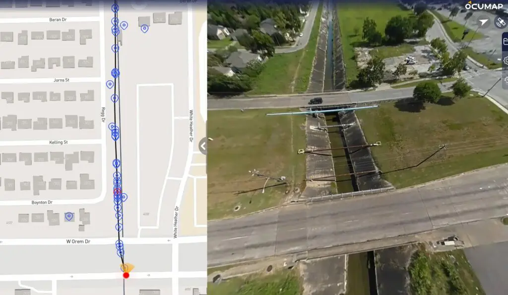
Aerial video mapping utilizes drones equipped with high-resolution cameras and LiDAR sensors to capture data from an aerial perspective. This technique is particularly beneficial for:
- Large-scale projects: Mapping sprawling infrastructure networks, construction sites, or vast landscapes is efficient and cost-effective with drone mapping.
- Topographical surveys: LiDAR data allows for precise measurements of land elevation, crucial for creating detailed terrain models.
- Inspections of hard-to-reach areas: Drones can safely access areas like rooftops or hazardous environments, capturing data for inspection and maintenance purposes.
Benefits of Aerial Video Mapping:
- Improved Construction Planning: 3D models generated from aerial data support informed site planning, volume calculations for earthwork, and visualization of construction progress.
- Enhanced Environmental Monitoring: Monitor land cover changes, track deforestation, and assess environmental impact of development projects with high-resolution aerial imagery.
- Streamlined Disaster Response: Quickly capture detailed aerial imagery of disaster zones to assess damage, prioritize resources, and facilitate rescue and recovery efforts.
Conquer Aerial Mapping in 3 Simple Steps with OcuMap
Tired of complex aerial data analysis? OcuMap streamlines the process! Here’s how to unlock the power of your aerial photos and videos in just three steps:
- Capture More, Analyze Later: Reduce Flight Time – Maximize efficiency by capturing GPS-enabled video during your flight. Bring it back to the office and use OcuMap’s user-friendly interface for in-depth location analysis. No need for extended flight times to collect precise data.
- Seamless Navigation and Comparison: Gain Instant Insights – OcuMap instantly displays your captured data on a map. Effortlessly navigate between images or videos, allowing you to compare your data with satellite maps and identify changes over time. Gain a clear picture of your entire project area without leaving your desk.
- Effortless Geotagging and Assessment: Simplify Data Management – Tag specific points of interest directly on your photos or videos with a single click. OcuMap automatically locates and pins these points on the map, generating a georeferenced database. Perform visual condition assessments directly from your office, saving valuable time and resources.
What is Utility Mapping?
Utility mapping focuses on creating detailed 3D models of underground infrastructure networks, including:
- Power lines
- Water pipes
- Gas pipelines
- Communication cables
Benefits of Utility Mapping in the USA:
- Reduced Risk of Accidental Damage: Accurate utility maps prevent accidental damage during construction projects, minimizing service disruptions and costly repairs.
- Improved Maintenance Planning: 3D models allow utility companies to identify potential maintenance issues and plan proactive repairs, leading to increased efficiency and reduced downtime.
- Enhanced Public Safety: Emergency responders can access utility maps to locate underground infrastructure during emergencies, expediting response times and safeguarding public safety.
Top Utility Mapping Solutions in the USA in 3 Simple Steps with OcuMap
- Drive-by-Imagery Verification: Verify critical asset locations with panoramic imagery from moving vehicles.
- Desktop Condition Assessment: Evaluate electric distribution circuits from street level for accessibility constraints.
- Enhanced Operational Efficiency: Increase reliability and efficiency by up to 30% with synchronized GIS and SAP databases.
What is Railway Mapping?
Railway mapping utilizes 3D mapping technology to capture and analyze data related to railway infrastructure. This includes:
- Tracks and switches
- Signal systems and overhead wires
- Stations and platforms
- Surrounding topography and vegetation
Benefits of Railway Mapping in the USA:
- Improved Safety Inspections: Detailed 3D models allow for thorough inspections of railway tracks, identifying potential safety hazards like track defects or vegetation encroachment.
- Enhanced Maintenance Planning: 3D mapping facilitates proactive maintenance planning by identifying sections of track requiring repairs or upgrades.
- Streamlined Infrastructure Expansion: 3D models support planning and design of railway expansions, optimizing route alignments and minimizing environmental impact.
Railway Mapping Solutions with OcuMap
- Virtual Track Inspection – Bring the entire track onto your desktop and revisit it as many times as needed
- Locate Above Ground Assets – Generate an asset inventory of all above ground utilities with a single run
- Off the Shelf Camera – Use any GPS-enabled camera to record GPS videos or GPS imagery
- Organize your Track data – See alignment, stations, MPs and Xings on videos and on map data.
What is Environmental Mapping?
Environmental mapping utilizes 3D mapping technology to create digital representations of natural landscapes and ecosystems. This data is used for:
- Habitat mapping: Identify and map critical habitat areas for endangered species.
- Forestry management: Assess forest health, monitor deforestation, and plan sustainable forestry practices.
- Landslide and erosion control: Analyze terrain data to identify areas prone to landslides or erosion for risk mitigation planning.
- Coastal management: Develop 3D models of coastlines to study the impact of sea level rise and coastal erosion.
Benefits of Environmental Mapping in the USA:
- Improved Conservation Efforts: 3D models provide valuable data for environmental scientists and policymakers to develop effective conservation strategies.
- Enhanced Resource Management: Mapping helps manage natural resources like forests, fisheries, and water resources more sustainably.
- Better Disaster Preparedness: Detailed terrain models support preparation for natural disasters like floods and wildfires.
Environmental Mapping Solutions with OcuMap
- Mapping Wetlands, Waterways, and Land: Utilize GPS-Based Media to Survey Environmental Features
- Efficient Data Collection: Capture Data on Foot, Bike, or Aerial Surveys
- Tagging Points of Interest: Enhance Decision-Making with GPS-Tagged Features
- Flexible Data Publishing: Control Data Access and Distribution for Enhanced Insights
Conclusion
3D mapping software empowers professionals across diverse industries to visualize, analyze, and manage their projects and environments with unparalleled efficiency and precision. By harnessing the power of 3D mapping, businesses can streamline workflows, optimize resource allocation, and make informed decisions to drive success.
This comprehensive guide serves as a valuable resource for anyone seeking to understand the transformative potential of 3D mapping software. With the changing technology, 3D mapping is poised to revolutionize the way we interact with and manage the world around us.