The need for accurate, reliable, and efficient utility mapping services has never been greater. As urbanization continues to accelerate and infrastructure ages, the demand for advanced utility mapping solutions in the US has surged. Utility mapping services provide crucial data that supports the planning, design, construction, and maintenance of utility networks, ensuring that our cities and towns run smoothly.
What is Utility Mapping?
Utility mapping is the process of identifying and documenting the location of underground and above-ground utilities. These utilities can include water, sewer, gas, electric, telecommunications, and more. By accurately mapping these assets, utility companies, construction firms, and municipalities can avoid costly and dangerous mistakes during excavation and construction projects.
The Importance of Utility Mapping Services
- Safety: One of the primary reasons for utility mapping is to enhance safety. Striking a buried utility line can lead to catastrophic consequences, including explosions, service interruptions, and even fatalities.
- Cost Savings: Accurate utility maps help avoid unnecessary digging and repairs, reducing project costs significantly. It also minimizes the risk of legal liabilities associated with accidental utility damage.
- Efficiency: With precise utility mapping, projects can be completed faster and more efficiently. Knowing the exact location of utilities allows for better planning and execution.
- Regulatory Compliance: Many jurisdictions require utility mapping as part of their regulatory framework. Compliance with these regulations ensures that projects meet legal standards and avoid potential fines.
The Rising Demand for Utility Mapping Services in the US
The utility mapping industry in the US has experienced substantial growth in recent years, driven by several factors:
- Infrastructure Modernization: The US government has been investing heavily in infrastructure modernization. This includes upgrading aging utility networks to enhance reliability and efficiency. Accurate utility mapping is a critical component of these projects.
- Urbanization: As more people move to urban areas, the demand for reliable utility services increases. Utility mapping helps cities manage their infrastructure more effectively, ensuring that services keep pace with population growth.
- Technological Advancements: Advances in technology, such as Geographic Information Systems (GIS), Ground Penetrating Radar (GPR), and LiDAR, have revolutionized utility mapping. These technologies provide more accurate and detailed maps, driving the demand for sophisticated mapping services.
- Environmental Concerns: Utility mapping also plays a role in environmental protection. By accurately mapping utilities, projects can minimize their impact on natural resources and reduce the risk of environmental contamination.
Latest Statistics on Utility Mapping Software in the US
According to a recent report by MarketsandMarkets, the global utility mapping market is expected to grow from $3.2 billion in 2020 to $5.3 billion by 2025, at a Compound Annual Growth Rate (CAGR) of 10.7% during the forecast period. The North American region, particularly the US, is projected to dominate this market due to the increasing adoption of advanced mapping technologies and significant infrastructure investments.
A study by Grand View Research highlighted that the US utility mapping software market alone was valued at over $1 billion in 2022 and is anticipated to continue growing at a steady rate. This growth is driven by the rising demand for utility infrastructure management, urban planning, and disaster management.
Key Technologies in Utility Mapping
Several cutting-edge technologies are driving the evolution of utility mapping services:
- Geographic Information Systems (GIS): GIS technology allows for the visualization, analysis, and interpretation of spatial data. It provides a comprehensive view of utility networks, making it easier to manage and maintain them.
- Ground Penetrating Radar (GPR): GPR is a non-invasive method used to detect underground utilities. It uses radar pulses to create detailed images of subsurface structures, helping to identify the location of buried utilities accurately.
- LiDAR (Light Detection and Ranging): LiDAR technology uses laser pulses to create high-resolution 3D maps. It is particularly useful for mapping above-ground utilities and assessing the condition of infrastructure.
- Remote Sensing: Remote sensing technologies, such as satellite imagery and aerial photography, provide valuable data for large-scale utility mapping projects. These methods offer a bird’s-eye view of utility networks and their surroundings.
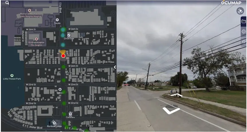
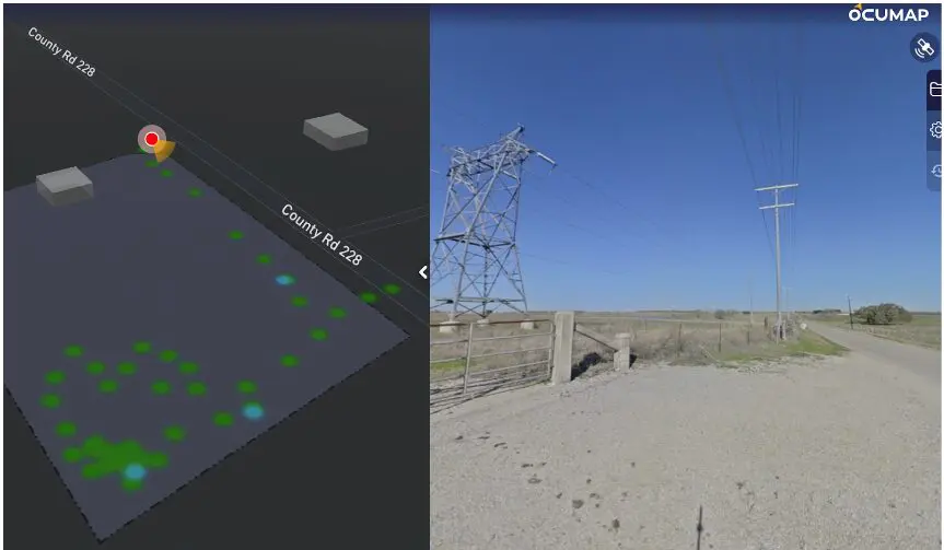
- Street Level Imagery taken from a moving vehicle with a 360 degree GPS camera.
Applications of Utility Mapping Services
Utility mapping services are utilized across various industries and applications:
- Construction: Construction companies rely on utility mapping to plan and execute projects safely and efficiently. Accurate maps help avoid utility strikes and ensure that new structures are integrated seamlessly with existing utilities.
- Municipalities: Local governments use utility mapping to manage public infrastructure. This includes water and sewer systems, streetlights, and communication networks. Mapping helps municipalities plan maintenance and upgrades, improving service delivery to residents.
- Utilities: Utility companies use mapping services to manage their networks more effectively. This includes electric, gas, and telecommunications providers. Accurate maps help these companies maintain and expand their services while minimizing disruptions.
- Environmental Management: Environmental agencies use utility mapping to monitor and protect natural resources. Mapping helps identify areas where utilities may pose a risk to the environment, enabling proactive measures to mitigate potential impacts.
Challenges in Utility Mapping
While utility mapping offers numerous benefits, it also presents several challenges:
- Data Accuracy: Ensuring the accuracy of utility maps is critical. Inaccurate data can lead to costly mistakes and safety hazards. Continuous efforts are needed to verify and update utility information.
- Integration with Existing Systems: Integrating utility mapping data with existing systems, such as GIS and SAP databases, can be complex. Seamless integration is essential for maximizing the value of mapping data.
- Data Management: Managing large volumes of mapping data can be challenging. Organizations need robust data management systems to store, process, and analyze mapping information effectively.
- Cost: Implementing advanced utility mapping technologies can be expensive. Organizations must weigh the costs against the benefits to determine the best approach for their needs.
Future Trends in Utility Mapping
The future of utility mapping is bright, with several trends shaping the industry:
- Artificial Intelligence (AI) and Machine Learning (ML): AI and ML technologies are being integrated into utility mapping to enhance data analysis and predictive capabilities. These technologies can identify patterns and anomalies in mapping data, improving decision-making.
- Blockchain Technology: Blockchain technology offers a secure and transparent way to manage utility mapping data. It can provide a tamper-proof record of utility locations and conditions, enhancing data integrity.
- Internet of Things (IoT): IoT devices are increasingly being used in utility mapping. These devices can collect real-time data on utility conditions, enabling more proactive maintenance and management.
- Augmented Reality (AR) and Virtual Reality (VR): AR and VR technologies are being used to visualize utility networks in new ways. These technologies can create immersive experiences that help stakeholders understand the complexities of utility infrastructure.
The Role of OcuMap in Utility Mapping
OcuMap is at the forefront of utility mapping solutions, offering a fast and reliable platform for identifying and managing utility assets. Here are some key features of OcuMap:
- Fast & Reliable Utility Mapping Solution: OcuMap provides accurate and timely utility mapping services, ensuring that critical assets are documented and managed effectively.
- Utility Mapping Software: OcuMap’s software verifies the location of critical assets using drive-by imagery. It allows users to collect panoramic imagery or videos from a moving vehicle, visually documenting the location of electric distribution grids.
- Condition Assessment: Users can perform condition assessments from their desktop, evaluating the condition of electric distribution circuits from the street level. This helps determine accessibility constraints based on real-world conditions.
- Street Mapping Software: OcuMap’s street mapping software enables comprehensive street asset inventory management. It helps identify potential system reliability upgrades and increases operational efficiency by 30%.
- Data Integration: OcuMap ensures that GIS and SAP databases are in sync. It helps obtain new asset data required for advanced operational functions, installation, and maintenance.
- Imagery Collection Support: For organizations needing help collecting imagery, OcuMap offers support to ensure that all necessary data is captured accurately and efficiently.
Conclusion
Utility mapping services are essential for the efficient and safe management of utility networks. As the demand for these services continues to grow, driven by infrastructure modernization, urbanization, and technological advancements, the role of accurate and reliable mapping becomes even more critical. OcuMap stands out as a leader in the utility mapping industry, offering advanced solutions that enhance operational efficiency, safety, and data accuracy. By leveraging OcuMap’s innovative technologies, organizations can ensure that their utility networks are well-documented and maintained, supporting the smooth functioning of our cities and communities.
For more information on how OcuMap can help with your utility mapping needs, visit OcuMap.