How to document assets within your city using an off-the-shelf GPS camera
Street Asset Management is no longer restricted to highly-trained professionals, but to the masses: with a GPS camera, and OcuMap, you have everything you need to go out and document infrastructure assets.
What is Transportation Asset Mapping?
Transportation asset mapping or inventory mapping refers to the process of collecting spatially referenced data of dispersed assets such as street signs, trees, lighting, sidewalks, rail tracks etc. and generating a digital inventory of their type, condition, and location. This is typically done to compliment a larger effort involving infrastructure asset management, mobility planning, smart city planning, and maintaining existing infrastructure.
While there are different methods used to collect spatially referenced data, for the purpose of this article, we will focus on street level data collection, walking, driving or biking, referred to as mobile mapping. Historically, street level mapping systems or mobile mapping systems were limited to LIDAR and visual cameras, where cameras were used to compliment LIDAR data and help the feature extraction team locate assets and defects visually. LIDAR, short for light detection and ranging, is a popular remote sensing method used for measuring the exact distance of an object on the earth’s surface. In mobile mapping, LIDAR data is captured using laser scanning equipment mounted on a moving vehicle.
However, recent software developments and algorithms enable end users to extract features directly from GPS-based imagery only. A software-as-a-service solution such as OcuMap for example eliminates the need for LIDAR by relying on GPS triangulation to extract assets directly from street level imagery, making it a cost-effective solution. In addition, companies or cities can now deploy off-the-shelf GPS cameras to collect data at their own pace without relying on costly LIDAR experts and equipment.
Street level mapping systems and different levels of flexibility
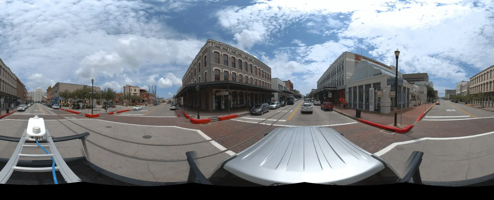
Nowadays, street level imagery can be captured in different ways. Where the early days were all about car-based mapping, it’s now possible to use a backpack, or use a bike or motorcycle with nothing more than a GPS camera. Because the camera’s GPS is able to georeference the imagery, tagging it with an x,y,z location, the user can always relate the imagery and visible content to a location on a map. This makes it possible to document assets within a city using any GPS camera, upload it to the cloud and extract the assets directly from the imagery.
Since high-end mobile mapping systems consist of integrated hardware and software systems, there’s no option to use other tools than the ones provided by the manufacturer. Luckily, users looking for solutions that do offer such flexibility don’t need to look any further than Ocumap’s solution, which gives them the freedom to use their GPS camera of choice for capturing street level imagery.
How to locate Street Defects from a moving vehicle
Infrastructure defects vary in type, shape and location, depending on the use-case. The fastest and safest way to locate these defects is through mobile mapping using a panoramic GPS camera. The panoramic camera is able to record full motion video of the entire right-of-way that can be later viewed from the office for further analysis. After uploading the data, the person doing the assessment can visually locate defects directly from OcuMap. Each defect is associated with GPS coordinates and a comment section to help stakeholders better understand existing conditions. An example of defects includes road cracks, broken sidewalks, tilted street signs, etc. Doing so using conventional survey methods on foot is deemed dangerous and time-consuming. Therefore, being able to drive and collect the spatial data is far more superior.
What do you do with large volumes of street-based imagery for your projects?
In order to be able to visualize and analyze large amounts of street-based imagery, it needs to be stored somewhere, preferably in an environment where users are not restricted in terms of data volumes. Because imagery in general is large in size, one can imagine that large amounts of it require significant terabytes or even petabytes of disk space.
Before organizations had global internet access, they would produce massive amounts of digital files that would be stored away on local hard drives or servers. Nowadays, users want to be able to work anywhere, thanks to high-bandwidth internet and cloud-based servers. This calls for an environment where large datasets can be uploaded and accessed quickly, just like email, data portals and websites. OcuMap’s software-as-a-service was designed to free organizations from keeping massive archives of data onsite, but instead offer a cloud-based, safe working environment where data is uploaded and can be accessed from anywhere in the world using a web browser.
Capturing, storing and accessing roadway inventory- How to do it right
Ideally, your organization uses a street-mapping solution that enables you to capture, store and access roadway inventory as quickly and easily as possible, so that different stakeholders, such as engineers, city planners, and public maintenance teams always have the most up-to-date information at their disposal. This will not only save your organization time and money, but it will help you solve problems in the field quickly, take away riskful situations and create a safer environment for local citizens.
OcuMap was developed to help stakeholders capture, store and access their road inventory easily and efficiently, offering them all the tools they need using a clear and intuitive interface that feels right from the beginning. The application shows you the street level images on a map, so that’s clear where the roadway inventory is located. Metadata for each image enables you to describe the state of the inventory and if any immediate action is required from field work crews. Taking your street-based imagery to the cloud, OcuMap lets your organization streamline visual inspections and asset inventories in a secured, protected and user-friendly way.
For more info, reach out to us here