Street view Imaging for railroads streamlines planning & Inspections
Every railroad corridor requires a set of fiber optics cable network in order to keep it running. Like any other construction project, installation of a fiber optics cable network requires a thorough survey of the entire place in order to know the environment, dimensions, and condition. This is necessary for both, the initial installation task and the maintenance activities that follow the railroad condition assessment. Lets see how Railroad Panoramic Imaging can help streamline the process.
Conventional Railroad Surveys Take Time
Conducting the conventional surveys for fiber optics installation would mean dealing with a number of issues. Some of these include:
- You need to invest a lot of time along with other resources.
- It becomes a costly project since surveying miles of railway track would need highly advanced tools.
- One would need to make use of the most trained people for this task.
- Also, traditional surveys might disturb or hamper the normal workflow or transportation in that particular area.
So, what could be a possible solution? The need of the hour is using a more advanced technique to conduct the survey and collect the necessary details. One potential solution could be performing the required survey based on imagery produced along the rail track. This is an authentic, efficient, verified and a feasible method.
What is Railroad Panoramic Imaging?
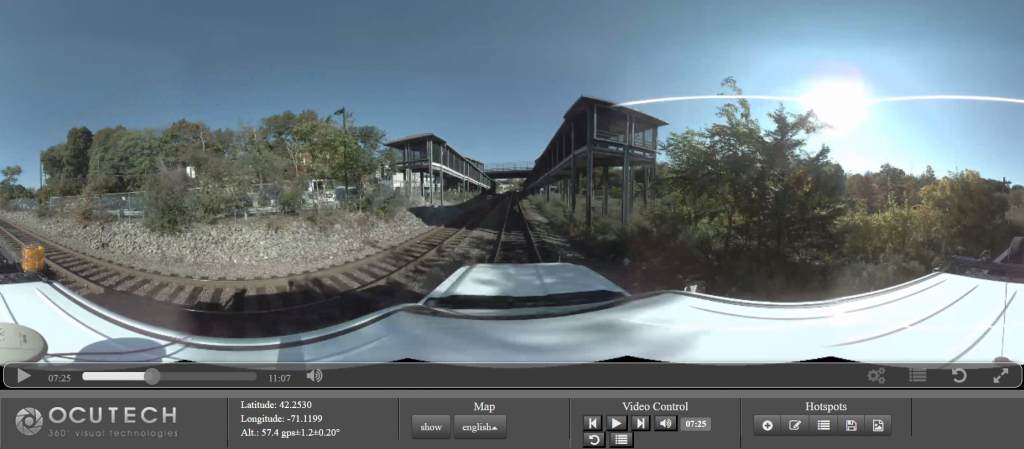
Commuter Railroad Panoramic Imaging is a technique which reproduces images and pictures from the railway track on the computer screen for further processing. Here is how it is done:
- There is an omni-directional camera that is set up for capturing the railroad images. Installing this recording device does not take more than 10 minutes. This camera on the high rail vehicle helps in taking survey pictures.
- Recording starts on the camera with the push of a button. This can be done by the trained and professional crew members on the mission.
- The device can collect miles of railway track imagery in a single day and display it on the screen. For this, the processing team processes the recorded imagery into individual shots or motion picture videos. This takes approximately 24 hours for the entire project to be retrieved and processed.
- The processed imagery/video is then made accessible to the project team using a single URL. Further editing and changes can be conducted over video as needed. For instance, certain portions or areas of the video can be marked out or highlighted. This area will then be tagged with its GPS coordinates and be made accessible to the rest of the team.
- Now, other aspects of the survey can also be completed with the help of this method. For instance, the trained personnel can make horizontal or vertical measurements on the images/video. This will help you have an idea of the dimensions of the concerned zone. What this does, is allows you to assess the site from a distance, on a virtual platform without actually being physically there. The right of way survey can be completed within + or – 15 cm positional accuracy.
How Does Commuter Railroad Panoramic Imaging Help?
This type of a railroad street view really helps contractors conduct surveys and take a virtual tour of the area. Here are some ways in which this technology is beneficial:
- The images/videos collected from the railway tracks using this method provide a 360-degree panoramic view. This means that without even visiting the location, you can have a good idea of the dimensions, conditions, and terrain for the right of way. This proves to be a big advantage for contractors and project owners.
- When you take help of this imagery received from railroad cameras, the different terrain conditions and constructions are well represented here. For instance, if there is a bridge built in the path of the rail track, it can be well captured by the camera. Add to that, you can geotag points of interest for structures like bridges, signals, access points, staging areas, etc.
- During a construction project, a lot of other measurements and ideas are also required. This includes checking the height of trees, neighborhood areas, soil type and conditions. This gives you an idea of how the construction can be undertaken in such area, and the kind of maintenance work that will be required once the project is complete.
- There is a vast amount of data that can be generated using this technique. This reduces human labor, time and expenses. For instance, using the conventional methods, it would be difficult covering more than a few miles a day in your survey. However, using the street view panoramic mapping technique, as many as 35 miles can be covered in one day, and brought to your computer screen within 24 hrs.
- Street view for railroads can streamline the ROW inspection process using visual documentation with location intelligence. It also satisfies some of the regulatory requirements set forward by the Federal Railroad Administration.
Railroad Panoramic Imaging the right way
Considering the benefits offered by these railroad street view cameras, this technology is highly recommended for all kinds of construction projects. The idea is simple. All one needs to do is fit 3D cameras onto high rail vehicles that are able to drive over the train tracks. In this way, footage of the track and road are captured on the 3D cameras. The data is then processed, edited and put to use for various purposes.
There have been quite a few such successful projects in this regards. Miles of railroad tracks have been covered passing through several districts, mountains, and cities. Different countries and their governments are taking up to the idea of this right of way video mapping technology.
Even though this is one of the best ways to capture the street level imagery for right of way, there are some other challenges that follow. For instance, the panoramic images/videos are best shot during the day, however, there are ways to add lights to the camera rig to make it operational in dark areas such as tunnels and underpasses. Lastly, it is also important to handle the flow of data correctly. For instance, the 3D camera might be able to take as many as 20,000 images in a single run, and having the right device to record, store, and process this data becomes an essential part of the task.
OcuMap has extensive experience mapping hundreds of miles of commuter rail tracks using panoramic imaging technology, thus boosting their productivity and efficiency. To know more as to how OcuMap can help your organization through its innovative ideas, contact us today!