OcuMap’s new OcuMap software provides a great solution for drone companies looking for comprehensive video data management software. This article explains how drone companies in the mapping and surveying space can upload, manage and share drone video imagery within their organization.
Google Street View & Georeferenced Drone Imagery
Imagine a combination of Google Street View and drone imagery. Add a number of georeferencing capacities to that and you have OcuMap, a 360 degrees cloud-based viewer for aerial and street level imagery. The OcuMap software has been developed and released by Reality Imaging and Mapping Technologies, an all-inclusive provider of visual technology solutions from Houston, Texas.
Drone companies in the mapping and surveying industry could benefit greatly from OcuMap, which allows them to upload drone video imagery to the cloud, view it in the application and share it with other stakeholders. The software is hardware-agnostic, which means that a variety of cameras can be used with the software: OcuMap supports display of any stitched 360°.mp4 video up to 4K in resolution, as well as stitched 360° images in jpeg format, flat video in .mp4 and flat images in jpeg format.
Uploading and Managing Drone-based video imagery
The OcuMap application gives access to an online project page, after signing in with the user’s login credentials. A project page lists various project folders, that is comparable to any other file management system. Users can upload video, GPS and map files in .kml and .kmz format. Drone users need to specify the angle of the camera when uploading video imagery, as the software is meant for 360 imagery. By specifying the amount of degrees that a front-looking camera is from the north, the user makes sure the orientation is correct. The same screen enables users to toggle between display of a compass, adding a 2D map view and the option for taking measurements inside the drone imagery. There are three different viewing modes for video imagery: “flat” for regular video and imagery, “normal” for spherical imagery and “cylindrical”.
After specifying folder settings, the video content can be uploaded. There are two upload options: a direct upload and a GPS parser. The direct upload option accepts coordinate files (.txt, .xml), and video file (.mp4) or image (.jpg). Georeferenced videos must be uploaded simultaneously with a GPS data file in .xml or .txt format, and both .mp4 and GPS file must have the same name so they can be referenced.
Using the GPS parser, a GPS file can be uploaded, such as a .csv file. OcuMap will show a preview of the rows and columns inside the .csv file, after which the user is required to specify the columns that contain the latitude and longitude data, as well as the time units used for data collection, that can be either “date/time” or in seconds. The latitude, longitude, altitude and time values are displayed next on the right side of the screen in a new table, so the user can check if the right fields are specified. The associated video file can be uploaded next.
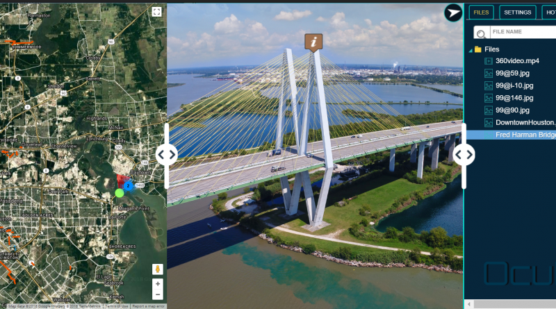
OcuMap’s Dashboard for Maps, Imagery and Video
The data view window is the main part of the application and consists of a single dashboard showing maps, imagery, and video data. The “view project” button in the project list window gives access to this dashboard, that shows a maximum of three windows, starting with uploaded map data on the left (or default Google Maps/Streetview data), the video in the middle and a file folder structure menu on the right. This last window shows all files, map bookmarks (called hotspots) and a search bar. A color settings menu offers basic settings for brightness, contrast, saturation. Users can navigate directly to hotspots on the map by clicking on a list item.
OcuMap is a 360 degrees viewer, which means that if the field of view in the map data is rotated, it will automatically rotate in the video data display as well. The map view shows latitude, longitude, altitude as well as the Field of View (FoV) orientation, as the user navigates through the video imagery. In case users want to skip parts of the drone video, they can drag and drop your position in the map data. A hotspot menu enables geotagging of points of interest, by clicking a location in the video and specify the name field. The flat viewing modus does not offer the geotag option, as geotagging is based on 360 viewing mode. All points of interest can be exported to a .csv file, so separate field values need to be specified using commas. Next, a pin is dropped on the hotspot, visible in both the map and the video. The accuracy is determined by the data: good GPS coordinates means good location accuracy.
Projects can be shared on three user levels per email: users can see the data in “view only” mode, make comments through a “comment” mode or make edits through a “modify” mode. A snapshot option takes a screenshot of the drone video imagery and downloads it locally. The same can be done with the csv data.
Why use OcuMap?
Organizations who have used the OcuMap platform were able to realize huge time savings, as it enables easy data access for those who need it most, such as decision makers in the office or field workers onsite. The solution has been used for corridor mapping, realizing significant efficiency gains in the city of Houston, Texas. OcuMap can be used in many different industries, whether in engineering and construction, petroleum, roads and transportation or local government.
Rather than offering difficult-to-use user interfaces, OcuMap is an easy-to-use and fully customizable solution that doesn’t require industry-specific expertise. OcuMap has the potential to become an all-in-one geospatial media viewer, including imagery, videos, and other 2D and 3D data types collected in one dashboard. It is not just a data management solution, but it also offers measurement and geotagging capabilities found in GIS software that speed up data management workflows. OcuMap is available as a customizable solution, offering export ArcGIS and OpenStreetMap support if necessary