Geovideo Inspection Technology
Geovideo! what is it? We have all been hearing the bad news about budget cuts in infrastructure maintenance and management. An issue that continue to challenge city managers and engineers around the world. In the State of Texas alone, local spending per capita is nearly double state spending, resulting in some cases in local debt as both municipalities and cities try to keep up with growth, and replace aging infrastructure. Most right of way inspection and maintenance projects require dedicated resources, and enough time to do the job right. As a result, cities and states are looking for a more efficient way to document, identify and prioritize infrastructure spending needs by employing emerging imaging and mapping technologies. The thought is to employ technology that can rapidly provide intelligence to decision makers, and help them streamline the inspection process. Geovideo has been gaining some momentum in the past couple of years as an efficient tool for corridor imaging and mapping. It is enabling engineers and inspectors to see assets remotely in the form of a georeferenced video. Geovideo can be taken from the air or the street level depending, on the asset of interest
GEOVIDEO IS MORE ACCESSIBLE NOW THAN EVER
Geovideos are becoming more accessible to commercial companies, especially after the FAA has taken multiple positive steps towards certifying pilots and setting up guidelines for commercial UAV operations. In the US alone, it is estimated that over 800,000 drone owners registered with the FAA to fly drones for commercial use. This large number of licensed pilots includes engineers, inspectors, surveyors and other professionals who see value in applying Geovideos and geoimages to increase efficiency. Depending on the purpose of the inspection, one might need to identify the level of geospatial accuracy needed before deciding on the right UAV specifications. Other things to consider might include the video resolution, time of flight, and payload. You can refer to UAV Selection Guide in Commercial Projects for the more on this topic. With the hardware being vastly available, let’s take a look at how the 4th largest city in the US benefited from Geovideo in their corridor inspections.
HOUSTON, WE HAVE A CORRIDOR INSPECTION PROBLEM
As one of the nation’s largest cities 4th in population, and 9th in land area, Houston’s drainage network extends over an area of nearly 1000 square miles. This area is difficult to maintain and time consuming to document, therefore expensive, to assess on foot. In addition, Houston’s average annual precipitation from rainfall is 45.28 inches (1.15 meters)
http://www.usclimatedata.com/climate-graph.php?id=ustx0617&system=american&title=1
How will Geovideo Streamline Corridor Inspections?
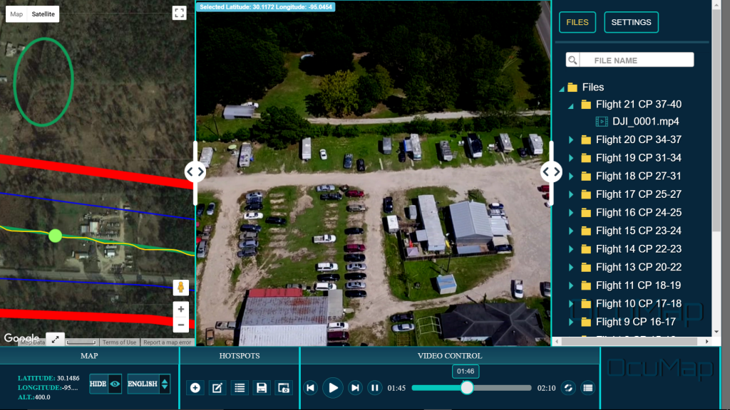
Houston undergoes significant rain events 106 days of the year, with possible flooding issues if the aging infrastructure is not prioritized, and maintained in a timely manner. This makes it very important to complete the assessment as efficiently as possible. The City of Houston’s Public Works and Engineering (PWE) department decided to take a new approach to imaging and mapping it’s infrastructure, in an effort to rapidly pin point the location of defects along it’s off-road ditches. The City teamed up with OcuMap to test out how Geovideo could be applied in identifying, prioritizing and maintaining the off-road ditches. The city had already developed an inspection plan that included the Geolocation of the off-road ditches and all attributes related to their maintenance. Planning operations and monitoring progress was crucial during this project. Efficiency metrics for Geovideo inspection needed to be established to help plan future projects, or dismiss the use case all together. Two approaches were tested out during this project, the first one was using aerial 360 degree Geovideo inspection, with a light weight 360 degree camera mounted on a UAV. The second approach was using the onboard camera of the UAV to collect Geovideo. Both results were satisfying however, one take away was that flat Geovideo provided enough field of view for the inspector to be able to see everything within the right of way. This finding ended up saving time on data processing, since 360 degree video could be large in size and may take longer to process into the right format. Besides aerial Geovideo, street level images and videos were also taken at different locations where it was safe and feasible for the inspector to walk it.
How Geovideo Solved Complex Inspection problems in Houston
With conventional inspections being done by experienced engineering inspectors, it would take about 8 months to document and prioritize the 100 mile long off-road ditch network of Houston. When comparing the numbers to the 45 day effort taken to visually document, map, and geotag defects using Geovideo, the inspection efficiency increased to more than 60% of previous years, leaving Houston with an optimistic future to resolve complex right of way inspections, at times when budgets are tight. The team at OcuMap used OcuMap to manage all the Geovideo data, tag defects online, and export the data into ArcGIS based on the priorities set forth by the City. This information enabled rapid accessibility of geospatial data to the engineers and decision makers, all from the comfort of their office. It also contributed to a better, and faster method for identification and prioritization of defects. Adding to the value and efficiency, Geovideo also served as a baseline reference for future planning, enabling project team members to compare past conditions to current conditions.
HOUSTON, WE DO NOT HAVE A CORRIDOR INSPECTION PROBLEM, Geovideo is here to help
It takes an unconventional team to start testing out and employing emerging imaging and mapping technologies. The City of Houston has been actively involved and on the leading edge of applying technology. The state of Texas spends nearly $6 Billion per year on public infrastructure, including highways and other repairs and maintenance activities however, even though budgets are tight, the demand to maintaining infrastructure is high, new technologies are surfacing every day trying to resolve complex inspection problems, and if cities are able to utilize these technologies to their advantage, the benefits will be realized immediately. Geovideo is a tool that helps increase the efficiency of complex right of way inspection projects, and save money, enabling localities to stretch tax dollars further. Houston, we don’t have a corridor inspection problem after all.