OcuMap Update: Improved (.csv) Export with Linkage to Tagged Asset Image
Houston, Texas, May 20, 2022 – Since its inaugural release in 2018, OcuMap has remained singularly focused on delivering value to owner/ operators who require timely, accurate, and visual documentation of their critical infrastructure assets. A cloud-based 360-degree viewer with georeferencing capabilities, OcuMap offers contributors a single dashboard with full access to maps, 360° video, and panoramic imagery in support of remote asset (feature) tagging and export.
“We digitize space in 3D and bring it onto the client’s desktop, leveraging Artificial Intelligence and Machine Learning technology, eliminating the need for multiple site visits,” says Founder and CEO, Ala Hamdan. “Our clients rely on us to deliver accurate infrastructure as-builts to streamline engineering design, construction, and asset management.”
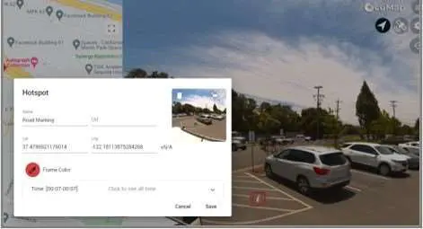
This latest update to OcuMap includes enhancements that streamline the workflow for seamless integration with 3rd-party GIS and asset management applications that accept input of geotagged asset (.jpg) imagery. Any geotagged point of interest (a.k.a. Hotspot) in OcuMap is automatically saved from the originally captured video. It can then be exported in (.csv) format with URL link to the tagged (.jpg) image. In all, the (.jpg) image, GPS position, and all attribute information is documented.

Reality IMT is continuously working across multiple industry segments and use-cases, enabling surveyors, engineers, GIS professionals, and other project stakeholders to fully visualize, and engage with their infrastructure assets.
For more information, visit:
www.ocumap.com/faq

